Working & Applications
Working
Synthetic aperture radar (SAR) refers to a technique for producing fine-resolution images from a
resolution-limited radar system. It requires that the radar be moving in a straight line, either
on
an airplane or,rocket. The basic principle of any imaging radar is to emit an electromagnetic
signal
(which travels at the speed of light) toward a surface and record the amount of signal that
bounces/echoes back, or “backscatters,” and it's time delay.
The SAR works similar to a phased array, but contrary to a large number of the parallel antenna
elements of a phased
array, SAR uses one antenna in time-multiplex. The different geometric positions of the antenna
elements are the result
of the moving platform now.
The wavelengths that remote sensing radars use to observe Earth’s surface are microwaves,
typically in the range of a few to tens of centimetres. Because the radar signal loses energy as
it travels – at a rate equivalent to the beam width (wavelength / antenna size) – by the time it
hits the surface, the beam has spread dramatically. For example, with a signal wavelength of 10
centimeters and an antenna of 10 meters in diameter, the beam width is 1/100 radians (0.6
degrees).
From an altitude of 1,000 kilometers, the resulting beam width on the ground becomes a
very large 10 km, producing an image resolution which is insufficient for most applications. SAR
is the solution to this dilemma as it can vastly improve the resolution.
SAR techniques take advantage of the fact that the radar is moving in orbit to synthesize a
virtual 10-km-long antenna from the physical 10-m antenna in the direction of flight. As the
radar moves along its path, it sweeps the antenna’s footprint across the ground while
continuously transmitting pulses – short signal bursts separated by time – and receiving the
echoes of the returned pulses.
As a target (like a ship) first enters the radar beam, the backscattered echoes from each
transmitted pulse begin to be
recorded. As the platform continues to move forward, all echoes from the target for each pulse
are recorded during the
entire time that the target is within the beam. The point at which the target leaves the view of
the radar beam some
time later, determines the length of the simulated or synthesized antenna. The synthesized
expanding beamwidth, combined
with the increased time a target is within the beam as ground range increases, balances each
other, such that the
resolution remains constant across the entire swath.
The SAR-processor stores all the radar returned signals, as amplitudes and phases, for the time
period T from position A to D. Now it is possible to reconstruct the signal which would have
been obtained by an antenna of length v · T, where v is the platform speed. As the line of sight
direction changes along the radar platform trajectory, a synthetic aperture is produced by
signal processing that has the effect of lengthening the antenna. Making T large makes the
„synthetic aperture” large and hence a higher resolution can be achieved
Application
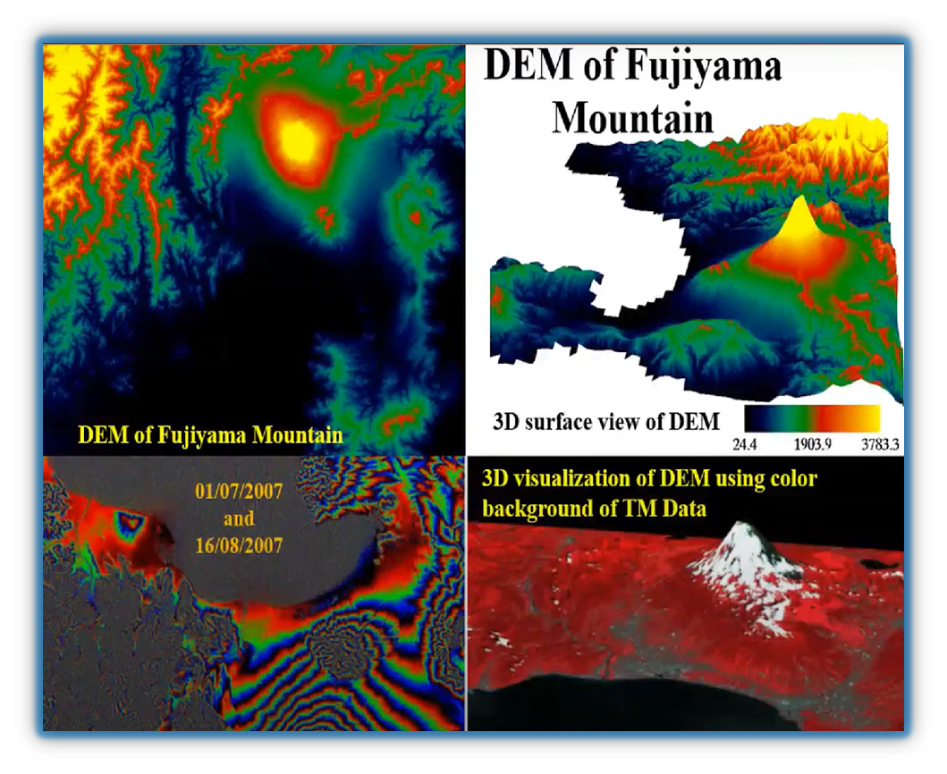
DEM which stands for Digital Elevation Model. Two technologies can be applied to generate DEM that are stereo SAR and interferometric sar. Stereo sar uses the parallax of sar pair to generate DEM; Interferometric sar uses the different phases of two sar images to estimate the surface height. A DEM for a large area can be generated without the need of ground control or a few control points.
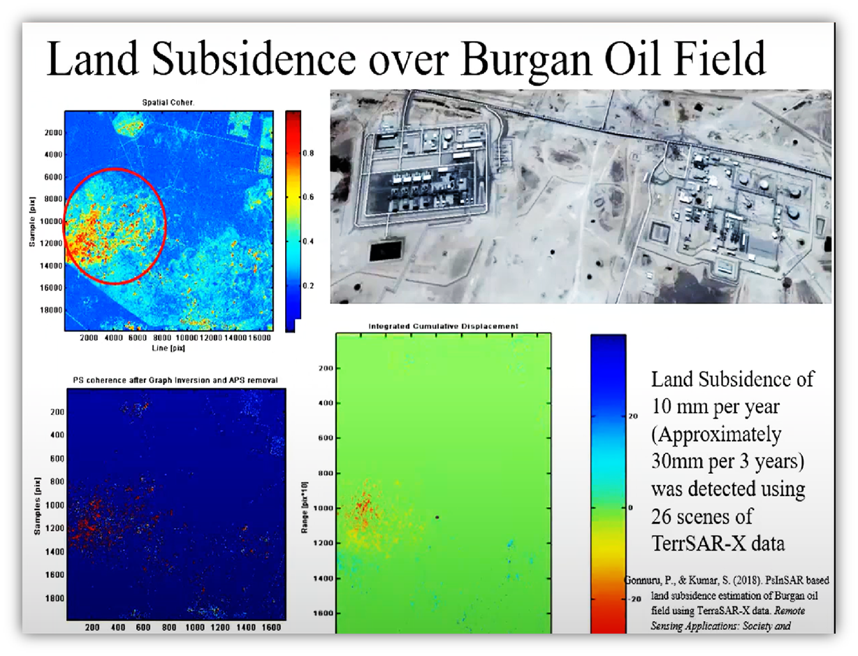
Di-In-SAR technology is used The millimeters level of accuracy can be obtained This technology is good for monitoring the construction site such as mining area, city…. It can help in predicting the hazards such as mining exploitation.
Soil dielectric constant is calculated through the sar backscattering signals.
The soil moisture content can be estimated by the soil dielectric constant.
The accuracy of the estimated result depends on the SAR wavelength, the polarization used.
It is useful for irrigation monitoring as well as environmental monitoring.
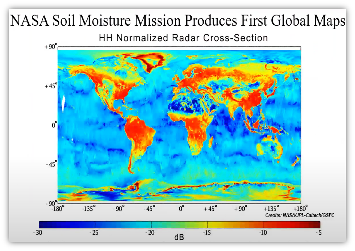
In the image you can see
The SMAP radar image acquired from march 21 to april 3rd 2015. Weaker radar signals
(shown in blue) reflect low soil moisture or lack of vegetation such as deserts.strong radar
signals (shown in red) are
seen in forests. SMAP’S radar also takes data over the ocean and sea.
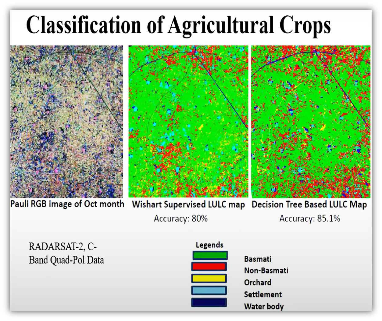
Multi temporal SAR data should be used to monitor the plant growth and the plant’s biomass. The damaged area due to flooding can also be monitored. The crop producing model may be used to stimulate the plant growth and predict the crop yields.
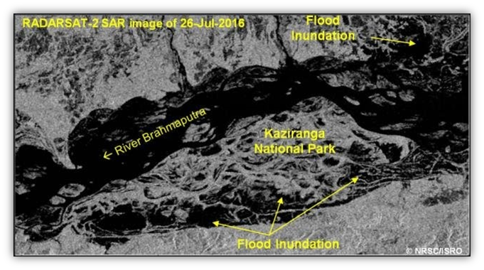
SAR data is weather independent. It can be obtained before, during and after the flood event. The flood area and flood effect area can be mapped. The flood movement can be delineated