
History
The major advantage of SAR is simple: Even the best aircraft-mounted or
satellite-mounted
optical camera is less useful
at night and useless when clouds or smoke are present. SAR can capture images at night
and
see right through clouds and
smoke. It is a 24-hour, all-weather technology.
Synthetic Aperture Radar (SAR) technology leverages a radar system installed on a moving
platform to generate two-dimensional images of the surface of the earth. SAR actively
illuminates the ground and uses the motion of the radar antenna over a target region to
provide finer spatial resolution than conventional radar.
SAR technology offers
many
advantages that traditional EO sensors can’t provide. In fact, high resolution imagery
is just one of many derived products that can be produced from SAR data processing.
Synthetic Aperture Radar, which was developed in the 1950s as a military reconnaissance
tool, was a solution to the 1940s need for an all-weather, 24-hour aerial remote
surveillance device the United States Army was looking for an aerial reconnaissance tool
which could see through clouds and would not depend on the hours of daylight.
Synthetic Aperture Radar (SAR) was invented by Carl Wiley at Goodyear Aircraft Company
in Goodyear, Arizona, in 1951. From that time forward, as the company became Goodyear
Aerospace Corporation, Loral Corporation, and finally Lockheed Martin Corporation, the
Arizona employees past and present played a long and storied role in numerous SAR
firsts.
These include the original SAR patent (known as Simultaneous Doppler
Buildup),
the first demonstration SAR and flight test, the first operational SAR system, the first
operational SAR data link, the first 5-foot resolution operational SAR system, the first
1-foot resolution SAR system, and the first large scale SAR digital processor. The
company has installed and flown over five hundred SAR systems on more than thirty
different types of aircraft for numerous countries throughout the world.
Carl Wiley, working at Goodyear, Arizona, (which later became Goodyear Aerospace, and eventually Lockheed Martin Corporation) in 1951, suggested the principle that — because each object in the radar beam has a slightly different speed relative to the antenna — each object will have its own doppler shift. A precise frequency analysis of the radar reflections will thus allow the construction of a detailed image.
Carl Atwood Wiley (December 30, 1918 – April 21, 1985) was an American mathematician and engineer. He is most widely known as the originator of the solar sail concept as well as the inventor of synthetic aperture radar. Carl Wiley, a brilliant if eccentric engineer, seemed an unlikely candidate to solve this puzzle and usher in the modern era of global reconnaissance. In the 1940s, he had been the first American scientist to propose a design for “space sails” to harness solar energy and propel space flight; he wisely published under a pseudonym. But by 1950, Wiley had landed at Lockheed Martin legacy company Goodyear Aircraft Company and tackled airborne radar as his latest challenge. Wikipedia


Emmett Leith, one of the pioneers of holography, believed that optical processing of the data could satisfy the requirement.In 1957, airborne synthetic aperture radar was yielding dramatic results, and the University of Michigan system had proven itself.
Leith was born in 1927 in Detroit, MI, the site of Wayne State
University where he would earn a BS in 1950, his MS in physics in 1952, and
his PhD
in
electrical engineering in 1978.
It was at the University of Michigan's Willow Run Research Center in the
mid-1950s
that
Leith reinvented holographic techniques.
Working on the then-classified
Project
Michigan, a synthetic-aperture radar system, Leith was tasked with optical
processor
research.
The concept behind radar-wave phase reconstruction inspired Leith to explore
wavefront
reconstruction for optical processing improvement.
Leith's work on optical processing as part of this project led to the first
coherent
cross-correlator and coherent optics to perform pulse compression of chirped
radar
pulses.
Wikipedia
In 1974, the National Oceanic and Atmospheric Administration and engineers from Jet
Propulsion
Laboratories began exploring the possibilities for oceanic observations using a
satellite
carrying a synthetic aperture radar.
SAR’s wavelengths make it sensitive to
small
surface
roughness changes, meaning that it is ideal for monitoring surface wave patterns and
currents.
SAR can measure displacement accuracy to within several
millimeters. The
June
1978 launch of Seasat was the first civilian application of synthetic aperture
radar,
and it provided a powerful new tool to scientists studying the earth
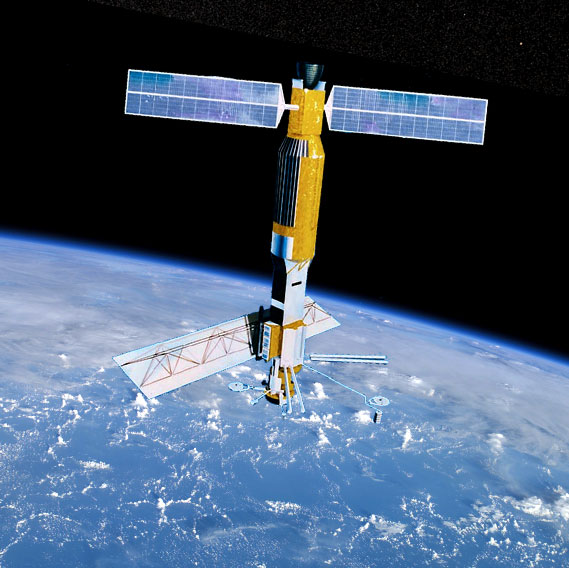
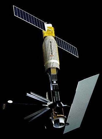
Seasat was the first Earth-orbiting satellite designed for remote sensing of the
Earth's
oceans and had on board one of
the first spaceborne synthetic-aperture radar (SAR). The mission was designed to
demonstrate
the feasibility of global
satellite monitoring of oceanographic phenomena and to help determine the
requirements for
an operational ocean remote
sensing satellite system.
Seasat was managed by NASA's Jet Propulsion Laboratory and was launched on 27 June
1978 into
a nearly circular 800 km (500 mi) orbit with an inclination of 108°.[2] Seasat
operated
until 10 October 1978 (UTC),[1] when a massive short circuit in the Agena-D bus
electrical
system ended the mission.
European Space Agency (ESA)
ERS-1
ERS-2
Envisat
Sentinel-1
Japan Aerospace Exploration Agency (JAXA)
JERS-1
ALOS-1
ALOS-2
Canadian Space Agency (CSA)
Radarsat-1
Radarsat-2
Radarsat constellation
National Aeronautics and Space Administration (NASA)
Seasat
NISAR
Ariel
Indian Space Research Organization (ISRO)
RISAT-1
NISAR (w/ NASA)
Deutsches Zentrum für Luft- und Raumfahrt e.V. (DLR)
TerraSAR-X
TanDEM-X
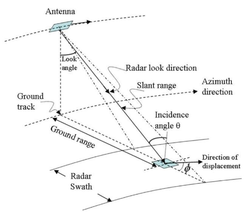
Azimuth Resolution :-
Azimuth resolution describes the ability of an imaging radar to separate two closely
spaced
scatterers in the direction parallel to the motion vector of the sensor.
Range Resolution :-
For the radar to be able to distinguish two closely spaced elements, their echoes
must
necessarily be received at different times.

Platform
When we are talking about the platform - most of the imaging by the Lidar system is done by airborne technique but when we are talking about optical multi spectral systems and SAR, imaging is done by both airborne as well as spaceborne techniques.
Radiation
Radar and SAR both are examples of active remote sensing techniques, so both will have their own electromagnetic radiation and that electromagnetic radiation will be transmitted towards the earth surface. Optical multi spectral Is kind of a passive sensor and the sensor is acquiring the reflected sunlight to the earth surface and the imaging is done.
Spectrum
In the case of lidar and Optical multi spectrum, infrared and visual infrared is used but in the case of synthetic aperture radar the microwave region of electromagnetic spectrum is used to do imaging.
Frequency
When we are talking about the frequency, lidar provides a single frequency data set Optical multi spectral will provide the data set in multi frequency mode. Means multiple frequencies will be there in each data set. The sar sensor can provide the multi frequency data set if the multi sensors will be used. One sar sensor is going to provide data in one frequency set. So there will be 2 major advantages of synthetic aperture radar, that is Use of polarimetric technique Use of interferometric technique

P-Band
The P band strengths include high penetration, detection of targets concealed by camouflage, and map forest disturbances.
L-Band
The L band has a frequency between 1215 to 1300 megahz- and has good penetration strength. Applications include land forestry, environmental monitoring, geology.
S-Band
The S band is a designation a part of the microwave band of the electromagnetic spectrum covering frequencies from 2 to 4 gigahertz (GHz). Thus it crosses the conventional boundary between the UHF and SHF bands at 3.0 GHz.
C-Band
The C band has the frequency between 5.25 to 5.57 ghz.C-band satellite communications suffer less from rain attenuation, but they require larger antennas and typically are used in Asia, Africa and Latin America.
X-Band
The X band has frequency between 9.5 to 9.8 ghz and is sensitive to surface roughness as its wavelength varies from 3.1 cm to 3.2 cm.