More About SAR
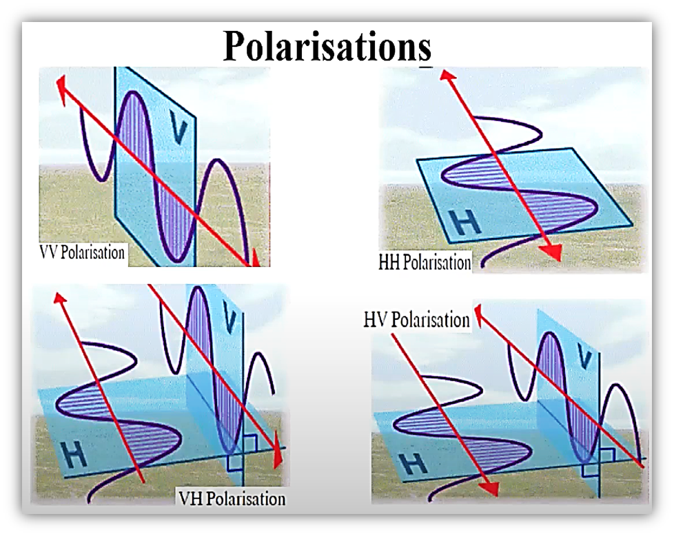
Radar Polarization
Unpolarized energy vibrates in all possible directions perpendicular to the direction of travel. Radar antennas send and receive polarized energy. This means that the pulse of energy is filtered so that its electrical wave vibrations are only in a single plane that is perpendicular to the direction of travel.the pulse of electromagnetic energy sent out by the antenna may be vertically or horizontally polarized.
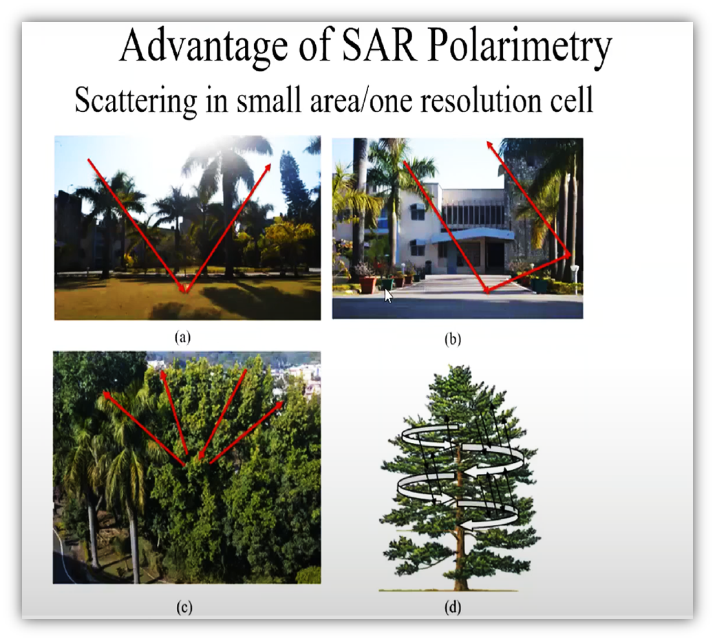
SAR Polarimetry is the science of acquiring, processing and analysing the polarisation state
of an electromagnetic field. SAR polarimetry is concerned with the utilization of
polarimetry
in SAR applications.
By varying the polarization of the transmitted signal and receiving several different
polarized images from the same series of pulses, SAR systems can gather detailed information
on the polarimetric properties of the observed surface, which can reveal the structure,
orientation and environmental conditions of the surface elements.
For example, linearly oriented structures such as buildings or ripples in the sand tend to
reflect and preserve the coherence (same linear direction) of the polarimetric signal
Polarimetric SAR has many applications in many fields, including agriculture (crop classification, soil moisture extraction, and crop assessment), oceanography (surface currents and wind field retrieval), forestry (forest monitoring, classification, and tree height estimation), disaster monitoring (oil spill detection, disaster assessment),
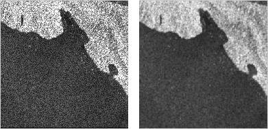
Speckle is a granular interference that inherently exists in and degrades the quality of the
active radar, synthetic
aperture radar (SAR), medical ultrasound and optical coherence tomography images. ... It is
caused by coherent
processing of backscattered signals from multiple distributed targets.
The vast majority of surfaces, synthetic or natural, are extremely rough on the scale of the
wavelength. Images obtained
from these surfaces by coherent imaging systems such as laser, SAR, and ultrasound suffer
from a common interference
phenomenon called speckle.
Speckle results from these patterns of constructive and destructive interference shown as
bright and dark dots in the
image.Speckle in conventional radar increases the mean grey level of a local area.[3]Speckle
in SAR is generally
serious, causing difficulties for image interpretation.[3][4] It is caused by coherent
processing of backscattered
signals from multiple distributed targets. In SAR oceanography, for example, speckle is
caused by signals from
elementary scatterers, the gravity-capillary ripples, and manifests as a pedestal image,
beneath the image of the sea
waves.
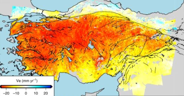
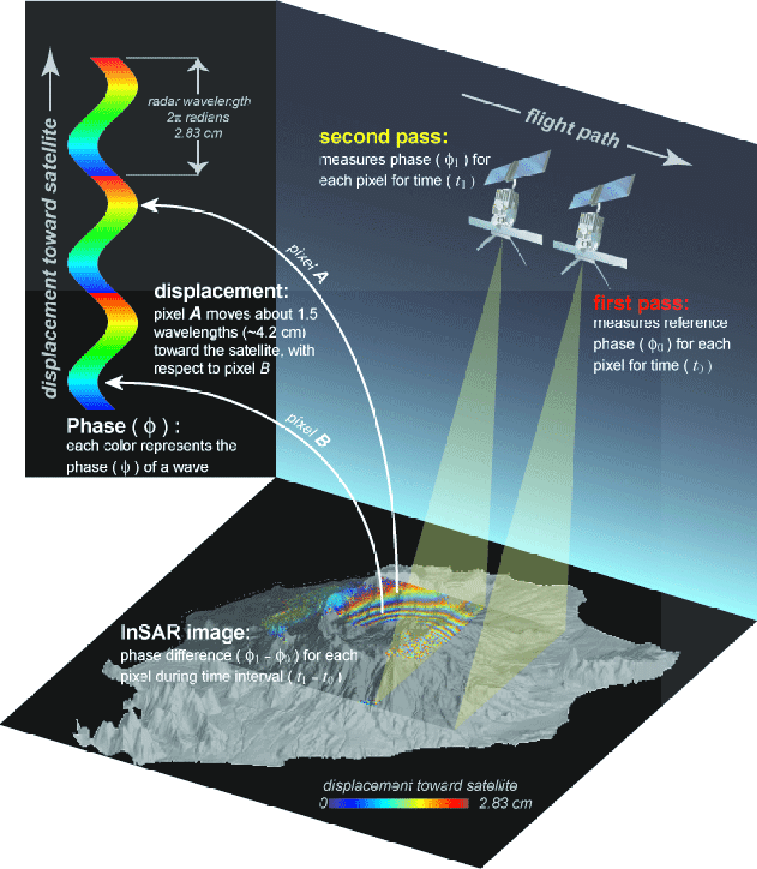
Interferometric Synthetic Aperture Radar (InSAR) is an effective way to measure changes in
land surface altitude. InSAR makes high-density measurements over large areas by using radar
signals from Earth-orbiting satellites to measure changes in land-surface altitude at high
degrees of measurement resolution and spatial detail (Galloway and others,
2000).
Synthetic
Aperture Radar (SAR) imagery is produced by reflecting radar signals off a target area and
measuring the two-way travel time back to the satellite. The SAR interferometry technique
uses two SAR images of the same area acquired at different times and "interferes"
(differences) them, resulting in maps called interferograms that show ground-surface
displacement (range change) between the two time periods.
InSAR is ideally suited to measure the spatial extent and magnitude of surface deformation
associated with fluid extraction and natural hazards (earthquakes, volcanoes, landslides).
It is often less expensive than obtaining sparse point measurements from labor-intensive
spirit-leveling and global positioning system (GPS) surveys, and can provide millions of
data points in a region about 10,000 square kilometers.
By identifying specific
areas of
deformation within broader regions of interest, InSAR imagery can also be used to better
position specialized instrumentation (such as extensometers, GPS networks, and leveling
lines) designed to precisely measure and monitor surface deformation over limited areas.